158 miles 29,000 vertical feet 39 days

The ultimate California kayaking expedition

Darin McQuoid and I crossed the proverbial finish line at Garnet Dyke Campground Friday evening capping off our nearly 6 week California Epic with the Middle Kings. Along with other West Coast Jackson Kayak expedition kayakers Devin Knight, Ryan Knight, Chris Korbulic, and Eric Seymour; and other noteworthy paddlers including Canadian phenom Corey Boux; Cali Veteran Taylor Robertson; Colorado Icons Gary Edgeworth and Forest Noble; Chris Gabrielli; extreme innertube guy Rolf Kelly; and Tim Kelton; Darin and I set a new Sierra precedent completing 12 of California's toughest runs in 39 days including 2 first Descents. After descending Fantasy Falls, West Cherry, Dinky Creek, South Fork Tuolumne, Grand Canyon Tuolumne, Poopenaut Valley of the Tuolumne, (first Descent) NF of the San Joaquin, Upper Cherry Creek, (first descent) Fish Creek, Middle Fork San Joaquin, and the Middle Kings through Kings Canyon we were exhausted to say the least.

All told the trip involved (per person):

1. 28 days of kayaking, 8 days shuttling vehicles, and 3 days of rest and feeding.
2. 73 miles of Hiking with expedition weight (70-80+)lb kayaks, climbing around 12,600 vertical feet.
3. 155 miles of class V - V+ kayaking Descending around 28,000 feet of vertical drop.
4. 20 nights spent out of our Hero and Super Hero.
5. $500 in Gas expenses and probably a few hundred more in brakes and wheel bearing work to Darin's 88' Nisan truck.
6. $200 to $300 in food of mostly overnight stalk. One of us likes generic and the other buys the organic brands so that's where the price differential comes in...

This expedition has obviously been more than a quarter century in the making as there is a plethora of information available on most of these expeditions from from the Pioneers like Lars Holbeck, Chuck Stanley, Don Banducci, Rick Fernald, Royal Robbins, Doug Tompkins, Newsome Holmes, Reg Lake, and Kenny Gould to the Driftwood and 7 rivers crews, but would not be complete without mentioning Jared Noceti and his crew for there South T first D and Rick Smith and Kevin Smith (not related) for their NFSJ recon.

With that said this trip would not have happened without ultra-motivated Darin McQuoid. Darin is now one of the, if not the, best and most able class V whitewater photographer in the business. He also saved us countless dollars while significantly reducing our carbon footprint by running many of the most daunting shuttles in California on his 1972 Yamaha dirt bike that gets 70 - 80 miles to the gallon. More importantly he provided the crucial beta that saved our asses on the hight water crucible run.

In addition to the 12 runs that I completed with Darin, he spent the 4 days before I arrived with the Knight Brothers on a high water Dinky Creek mission, a quick East Kaweah half day, and a late night speed run down the Disney Land like slides of South Silver. With just 3 or 4 years of class V expeditions under this guys belt, I can't wait to see what the future brings. Make sure to checkout jscreekin.blogspot.com and kayakphoto.com to see Darin's impressive body of work.

Also crucial to the success of our descents was the gear that Darin and I use. Jackson Kayak creek boats are the safest, most able, and most functional on the market. Werner paddles are the most durable and time tested paddle in the Universe. Kokatat PFDs and water wear are the choice of river professionals and the United States Coast Guard. Snap Dragon spray skirts were undefeated on this trip through high water descents and falls up to 75 feet tall. FNA helmets are the strongest, stiffest, and most durable helmet on the market. There is no better way to stay hydrated than with NUUN Hydration tablets. Annie's Mac and Cheese with Smoked Oysters is a river delicacy second to none.

Stay tuned to Jacksonkayak.com for photos and video from the the most recent contribution to the ultimate California itinerary The 8Th River Expedition.

Swelbows on the Edge

Swelbows on the Edge
Gary Edgeworth after 5 days on the Middle Kings. Eric Seymour Photo

Tuesday, September 9, 2008

August 30th, 2008: First Descent South Fork San Joaquin First Descent

In the 24 years that have passed since Royal Robbins, Doug Tompkins, Newsome Holms, and Reg lake's landmark first descent of the Middle San Joaquin, its sibling river the South Fork has been in the collective conscious of California's whitewater expedition elite. To further fuel the speculation over this run, it's upper reaches were included in the Holbek/ Stanley guide as a spectacular run that only gets "harder and more fun" the further you go down stream to a point where either a Heli flight out or a massive hike out is necessary. I believe that some one would have gone for it eventually in spite of Holbek's warning , but the flow information for this dammed and diverted river is closely guarded by the power giant California Edison.

This all changed two weeks ago when the proverbial leak at Cali Edison spilled the beans to AW rep Paul Martzen about a special 4 day release of 500 cfs down Mono Creek into the South Fork terminating at the same Mammoth Pool Reservoir that serves as a takeout for the crucible section of the Middle Fork.

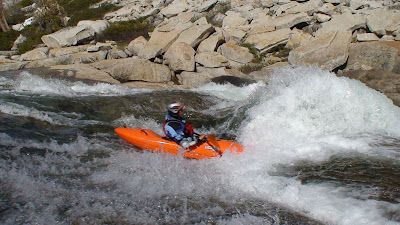
So with 2 days notice our challenge was simple. Put in on the Unrun and unknown lower reaches of Mono Creek and boat nearly 40 miles to the boat ramp at Mammoth Pool. The only thing that could possibly stand in our way would be a 9 hour journey to the take-out from Mount Shasta, another 4 hours of shuttling to arrive at the put-in at the Mono Creek Diversion Dam, and fabled granite gorges of the Lower South Fork. Of course we had to abandon the idea that the power company might altar the flow mid-run leaving us flooded out or high and dry in one of the most remote corners of the Sierra. That part of the bargain was simply beyond our control.

Huge shout out to my partners in crime Darin McQuoid, Matt Thompson, and the estimable Kevin Smith out of Mammoth whose intimate knowledge of the San Joaquin drainage is second to none. I'll attempt to let the video and Darin's upcoming TR at jscreekin.blogspot.com tell the rest of the story!

P.S. I'll let you guess which 2 of these cataracts were tested only by Mr. McQuoid.

Beta
Put-In: Mono Creek Diversion Dam (8100 feet)
Take-Out: Mammoth Pool Reservoir (3100 feet (low lake level))
Run Length: 40 miles (6 miles on Mono Creek, 20 miles on the South Fork, 6 miles on the Middle Fork, and 8 miles across Mammoth Pool)
Avg Gradient: 156 fpm
Shuttle Length: 4 hours (one-way)
Put-in Flow: 500 cfs
Take-out Flow: 650 cfs
Portages: 20 (all that I remember is a big one near the confluence)
Special Notes:
-Darin McQuoid went off on a first descent of the hardest run in California, Matt Thomas was reborn in the warm hole, and Kevin Smith a no-role descent.
-As you may have already noticed this descent falls well outside the specified 39 days that embodied the heart of the 8th River Expedition, but it is included none the less because of its relevance to the greater body of classic California expedition kayaking.

Sunday, September 7, 2008

July 6th, 2008: Middle Fork of the Kings

After a exhausting if not successful Fish Creek/ San Joaquin combo descent, Darin McQuoid and I were abot to hit the wall. In this case the wall refers to the 14 mile net 7000 vertical hike into the Middle fork of the Kings.

Despite taking only a single day in between pulling are boats off Mammoth Pool Reservoir, and setting foot on the Bishop Pass Trail head, Darin and I were fired up to significantly increase the size of our team with old friends from Wyoming, Colorado, and New Mexico. Eric Seymour and Gary Edgeworth rallied 13 hours from Jackson Hole, WY to the put-in while New Mexicans, Rolf Kelly and Tim Kelton, picked up whitewater legend Forrest Nobble at the Las Vegas airport half-way into their 20 + hour marathon drive to the take out continuing on for 7 more hours to the put-in. You can translate the effort put into the cross country drive to the quality and sheer magnitude of this run. There is no other descent in North America that seems to even come close to the kind of stats that the MFK puts up. 43 miles of Kayaking dropping over 7500 vertical feet with a paddle to portage ratio only challenged by the Fantasy falls run of the Mokelumne.

Everyday we wondered aloud how the hell Tommy Hilke and John Grace made it to the Yucca Point trail head in a single 19 hour push as we toiled for 5 days through one of the most beautiful and demanding whitewater runs on earth.

Beta

Hike In: South Lake TrH to LeConte Canyon (14 miles up 3000 feet down 38oo feet)
Put In: John Muir/ Bishop pass trail intersection (8600 feet)
Take Out: Garnet Dyke Camp Ground (1240 feet)
Run Length: 42 miles
Avg. Gradient: 180 fpm
Shuttle Length: 7.5 hours (one-way)
Put-In Flow: 175 cfs
Take-Out Flow: 1250 cfs
Portages: 13 (First Mank, 2nd choice*, Split decision, bottom of good morning 2o foot falls to start of exit gorge, big-bad beaver, 6 x bottom 9, 2 x Garlic Falls)
Special Notes:
- All of the portages are under 15 minutes long except one which was 20 minutes on a maintained trail.
- First known descent of Butter Buns aka Can of Crushed Ass.


*Still Unrun


Produced By Ben Stookesberry with Video By Rolf Kelly

July 1st, 2008: First Descent Fish Creek into the Middle Fork San Joaquin


Darin McQuoid and I were on the verge of California's equivalent of Baseball's complete game. Darin and I would only need two more descents to finish off the California expedition season having completed more first descents and high end classics in a single season than anyone before us. From Darin's previous year's descent of the Upper Middle San Joaquin, he new that the flow window was now open with the quickly dwindling flows on Upper Cherry Creek.

As it turned out, Chris Korbulic and Chris Gabrelli emerged from Upper Cherry mere hours after we blazed out our two day descent. The Chrises had spent 5 days enjoying U-cherry to it's fullest. Chris K made no fewer than 1/2 dozen descents of Cherry Bomb Gorge in attempt to live those 5 days to there fullest. Unfortunately, this would have dire consequences for the remaining 2 weeks of the California expedition season. No more than 1.5 miles into our Fish Creek hike his lower back was spasming. Another mile on and Chris pleaded no joy on the hike and the remaining 4 days that would prove to be the most arduous to that point.


Although Chris agreed to run our shuttle after hiking out (which would save us another full day of hiking and dealing), it was a significant blow to my confidence. Darin and I had just made a two day, two man descent of the Upper North Fork of the SJ and done fine, but this was the crucible, and every piece of the safety net that you could assemble would sooth a troubled mind. We had just lost a major piece of that safety net going into an unknown first descent that would culuminate in the hardest run in California: the Middle Fork of the San Joaquin.

Beta
Hike In: Fish Creek Trail (10 miles through Devils Postile Nat. Monument)
Put In: 6 miles up Fish Creek (6560)
Take Out: Mamoth Pool Reservoir (3318)
Run Length: 33 miles = 5 miles on Fish Creek + 20 miles on the Middle Fork + 8 miles on Mammoth Pool
Avg Gradient: 130 fpm
Shuttle Length: 6 hours (one-way)
Put-In Flow: 300 cfs
Take out Flow: 800 cfs
Portages: 16 (fish creek, 15 middle Fork)
Special note: Only a couple of the 15 portages we made on the middle fork took under 15 minutes, several pushed the one hour thresh hold.


Wednesday, September 3, 2008

June 27th, 2008: Upper Cherry Creek


As I eluded to in the Upper North Fork San Joaquin post, Darin and I used an amazing second descent as the principle rational for not running off to Upper Cherry like the rest of the herd. Soon enough however, my recollection from previous runs down the proverbial moonscape of class V kayaking got the better of me. More importantly my good bros from the State of Jefferson (Devin Knight, Ryan Knight, Garret Brown, and Matt Thomas) were making their weekend pilgrimage to the best that California had to offer. Unlike Matt and Devin that had been running rivers all over the Sierra that spring, Garret Brown was making just his second kayaking descent of the year with the first being another high end classic on the South Branch of the Middle Feather. It is also worth noting the descent itself. Devin, Ryan, and I were the only ones that had experienced upper Cherry before, yet we spent only two days, skipped the pre-scout of Cherry Bomb Gorge, and made a complete in boat descent of Arguably the most spectacular kayaking destination in the state.

Beta
Hike-In: Kibby Ridge TrH (11 miles gradually climbing 1500 feet)
Hike-Out: Upper Cherry Lake access (3/4 mile hike up 600 feet)
Put- In: 1.5 miles downstream from North/ East Cherry confluence (7150)
Take-Out: Cherry Lake (4700 feet)
Run Length: 9 miles
Gradient: 272 fpm
Shuttle Length: 20 minutes (one-way)
Put-In Flow: 120 cfs
Take- Out Flow: 300 cfs
Portages: Cherry Bomb Sieve* and Confluence Sieve
Special Note: Just like Disney Land with the occasional tough swim.
*Still unrun


Produced By Devin Knight and Ben Stookesberry

Wednesday, August 27, 2008

June 24th Upper North Fork San Joaquin


After the Lower North Fork Descent, there was no way in hell that I was going to go anywhere without completing the entire North Fork Run and finishing what we had started. Unfortunately Chris K and Chris G were obligated to meet up with friends on upper cherry the following day and were forced to bail on the would be second descent. However Darin McQuoid and I resisted the temptation to bail on the unknown upper Canyon of the North Fork for the known Ultra-Classic Upper Cherry run, and we were so glad that we did. Not only was Upper Cherry at a perfect flow the day after we finished the upper run, but the Upper Canyon in addition to our descent of the lower section cracked by top five list for California.


Beta
Hike In: Hemlock Crossing Trail (10 miles, 2000 feet up, and 2000 feet down into Bench Canyon
Hike Out: Sheep's Crossing Trail (3 miles and 1800 vertical feet up)
Put In: Hemlock Crossing (7900 feet)
Take Out: Sheep Crossing ( 6200 feet)
Run Length: 6 miles
Avg Gradient: 283 feet per mile
Shuttle Length: 5 minutes one-way
Put-In Flow: 100 cfs
Take-Out Flow: 300 cfs
Portages: 6 (log choked ledge, Boulder Chalk, hanging valley falls*, beefy notch rapid, landslide*, and power plunged).
Special Note: First descent of Porpoise like a Dolphin falls by Rick Smith with a second descent by Darin McQuoid.
*Still Unrun


June 21st, 2008: First Descent Lower North Fork San Joaquin


The North Fork of the San Joaquin has been on my too do list since the first time I attempted to find the fabled crucible in a newly purchased California Atlas and Gazetteer. With no mention of it in the Holbek/ Stanley guide, it stuck out as a large beacon of unknown real estate in the most dramatic drainage in California. After a brief conversation with Devin Knight (expedition Kayaker and Timberworks project manager) about the prospects of putting work off for another few weeks, I would finally have the time to turn my focus to this long sought after expedition. In it's entirety, the North Fork Remained untested by kayak until 1999 when Rick Smith reportedly made a run through the upper portions of the run. However, he stopped short of the confluence with the middle fork by 4 miles in order to avoid a section of river leading into the crucible at what was considered to be lethally high water.

Thus his hike out point at Sheeps Crossing would be our first point of entry to the North Fork inorder to claim the first descent to the steepest portion of the river down to the confluence with the Middle Fork of the San Joaquin. Our plan hedged on the prudence of a planned hike out at Cassidy Crossing 6 miles down the Middle Fork stopping just short of the fabled crucible. Making all of this possible really came down to the recollection of the river by Darin McQuoid from his descent of the Post Pile the previous year. He boldly guaranteed that we would be able to navigate the portion of the Devil's Post Pile of the San Joaquin from the North Fork Confluence to Cassidy Crossing at ultra high water.


Just having finished our Grand Canyon/ Poopenaut Valley epic Chris Korbulic was all in on the North Fork attempt along with our shuttle driver/ logestical coordinator from the Grand Canyon Chris Gabrelli. The crew would prove to be spot on descending the 400 fpm section through several locked in Gorges with at most a handful of portages. Huge props to Darin for his plan, and Chris Korbulic for carrying us through an un-scoutable un-portagable gorge in the middle of the North Fork.

Beta
Hike In: Sheep's Crossing trail (3 miles and 1800 feet down into the North Fork)
Hike Out: Cassidy Bridge (6 miles and 3500 feet out of the Middle Fork Canyon)
Put In: Sheep's Crossing (6200 feet)
Take Out: Cassidy Bridge (4500 feet)
Run Length: 9.5 miles (3.5 down the North Fork and 6 down the middle fork)
Avg. Gradient: 385 feet per mile on the North Fork
Put-In Flow: 300 cfs
Take- Out Flow: 1500 cfs
Shuttle Length: 15 minutes one- way from lower Granite Creek TrH to Sheep's Crossing TrH
Portages: 6 (1/2 of first 5+, 4 x in box canyon, 1/2 of sieve falls, good morning crack)
Special Notes: Cassidy bridge hike out kicked our asses for four to five hours.


Tuesday, August 12, 2008

June 18th, 2008: Poopenaut Valley Gorge


Compared to the most popular class V run in California (Cherry Creek Run of the Tuolumne), the upstream reaches of the Poopenaut Valley is one of the least known yet most accessible stretches of river in California. A quick detour from the Early Intake shuttle rout to the put-in below Hetch Hetchy Reservoir will provide inticing glimpses of classic Granite bedrock spilling forth from an imposing vertically walled black rock gorge. This gorge in conjunction with erratic flows from Hetch Hetchy make running the Poopenaut with adquate water a dicey proposition. The flows can drop from being too high to scout or portage to un-boatable fish-flows overnight.

When Chris Korbulic, Darin McQuoid, and I set shuttle for the Grand Grand Canyon run, the outflow from Hetch Hetchy equaled the inflow at about 1200 cfs. 3 days later it had dropped precepitously to 300 cfs. Our luck had been impeccable throughout the Grand Canyon but this took the cake. We would now be able to exit HH dam via river avoiding Yosemite checkout point on the road above.

Steady and predictable weather from late spring to early summer had allowed the Hetch Hetchy Authority to create a spill over event perfectly so as to lose minimal flow and let the reservoir come gently to full Pool as the last of the major snow patches to melt. The 300 cfs in the last 13 miles to the Holm Powerhouse would be the perfect low side of good flow. Increases in flow would increase the level of exposure dramatically, but also clean up otherwise sieved out sections of the river.

Beta
Put In: 1/2 mile below the Dam (3550 feet)
Take Out: Bridge at Early Intake (2150 feet)
Run Length: 14 miles
Avg. Gradient: 100 feet per mile (includes long stretches of flat water)
Shuttle Length: 45 minutes (one way)
Put-In Flow : 300 cfs
Take-Out Flow: 1000 cfs (Plus 700 from early Intake Powerhouse)
Our Portages: Cruise Ship* and several subterranean rapids*.
Special Notes: Worth doing once... or in combination with the GCT.
*Still Unrun


Thursday, August 7, 2008

June 16th, 2008: Grand Canyon Tuolumne


If there is a universal truth in the California's Sierra Nevada Mountains, it's that every major river drainage has a big, remote, class V canyon. From north to south expedition kayaker's choose from the most spetacular class V expeditions in the world: Bald Rock Canyon, Yuba Gap, The Royal Gorge, Fantasy Falls, Hells Kitchen, The Grand Canyon, Devils PostPile, The Middle Kings, and the Headwaters of The Kern. Of these 9 fabled whitewater descents, only one is prohibited by law.

Unlike the section of the same name
on the Colorado River, Grand Canyon of the Tuolumne has been set aside not for river runners, but instead for backpackers, horse packers, and the water consumption needs of over 2 million Bay area residents. Also unlike the more famous Grand Canyon of the Colorado that drops 2200 feet in 277 miles, the Grand T drops a whopping 4500 feet in just 18 miles. From here one should only make comparisons with the other California classics.

I found the overall portaging to be slightly easier than the Devil's Postpile. The whitewater is a mix of the classic section Downstream of Cherry Creek, the Devil's Postpile, and high end V+ more demanding than anything else in the Sierr's. But trumping both the arduous portaging and adrenaline of the GCT is a Scenery that is unmatched and must be scene to be believed.

Despite miles of quallity whitewater set in the Sierr's most spectacular chasm, the GCT is usually the last river on everyone's list. The Grand Canyon itself is patrolled by gun toting Yosemite Park Rangers and paddling across Hetch Hetchy to get to the take out is a federal offence. These issues implies a additional layer of logestical complication. Try entering the river in the middle of the night and sleeping for only a few hours till day brake in order to race through the Glen Aulin Ranger Station area before 7 am. Even still we lucked into a window between multi-day ranger patrols, leaving and entering the park in complete incognito.


Big thumbs up to Chris Korbulic and Darin McQuoid for shrugging off alot of bad beta and challenging logistics to make only the 3rd or 4th complete descent of the Grand Canyon T and first known descent in conjunction with the downstream canyons of the Poopenaut Valley.

Beta
Put-In: Hwy 120 Bridge in Tuolumne Meadows (8600 feet)
Take Out: Hetch Hetchy Res (3700 feet)
Run Length: 24 miles
Avg Gradient: 245 feet per mile
Shuttle Length (one way): 2.5 hours
Put-In Flow: 700 cfs
Take Out Flow: 1200 cfs
Our portages (4 miles): Cold Morning slide*, Tuolumne Falls*, White Cascade*, California Falls*, Brunch Slides, LeConte Falls*, Waterwheel Falls*, Freight train area*, Muir Gorge, (1/2) Hot Pockets*.
Special Notes: Needs water... Runnable before Upper Cherry is in. Don't Get caught above Glen Aulin.
*Still unrunn


Sunday, July 27, 2008

June 13th, 2008: South Fork Tuolumne Box

After a complete although crowded decent of the Waterfalls of Dinkey Creek Darin McQuoid and I were motivated to get off California's proverbial beaten path for a few weeks. To bide a bit of time before our next major overnight expedition, we decided to attempt a second descent of the South Fork T Box. Also game to try something new were Chris Korbulic, Evan Garcia, Drew Duval, and friend.

The beta I had was second hand from Taylor Robertson who in turn had chatted with Jared Nocetti. The report went something like... "amazing run, we made two repels but might not bring a rope next time." Assuming that my throw and go technique was as dialed as anyones, I thought we could pull it off with the use of throw bags and some "invent-a-jumps."

Well as the story often goes, I was wrong and we spent the better part of the Day pulling off the sort of free climbing maneuvers that should be reserved for valley rats in tight pants in order to hike our sorry asses out of the Box. Big props once again to Darin McQuoid for probing the escape root and setting a line to pull the boats back up the canyon wall.

This was were our fun met our frustration, and the following day Darin and I turned it into outright stubbornness. Making a half - day round trip in the blazing Cali heat, Darin and I drove to Sanora in order to secure a climbing rope. The following day we returned to the South Tuolumne Box with Chris Korbulic intent to finish what we had started.


Beta
Hike in: 1.5 miles down Confluence Road just downstream from the highway 120 bridge
Put In: Old Mocassin Tunnel (2660 feet)
Takeout: Lumsden Road (1440 feet)
Run Length: 2.5 miles
Avg. Gradient: 488 feet per mile
Shuttle Length: 45 minutes
Put In Flow: 150 cfs
Take out Flow: 151 cfs
Our Portages: Slide for your Life*, Lookout Falls*, misc. mank
Special Notes: If you want to portage you need a rope!
*Still Unrun

June 11th, 2008: Dinkey Creek

After only a day's rest in Mount Shasta, Darin McQuoid received word that Taylor Robertson was lining up a trip down the waterfalls of Dinkey Creek. With work still a few weeks off, I was not hard to convince to make the 7.5 hour push back south to get back in the line up for more of California's best whitewater. Incidentally following Taylor down one of his favorite runs is an experience to be had. You quickly will become intimately familiar with the lingo "turn two" and "come in hot" as he boat scouts you through some of the more memorable class V moments.

In the last 5 years, Dinkey Creek has gone from a Esoteric canyaking descent to arguably the finest slides and falls novelty run in the land. With that said, this run is a full notch harder than other novelties, ie South Silver, and if you are running everything the chances are high that you will be forced to swim at some point.

Also joining us for our descent on rout to his home in BC from the movie set in LA was Correy Boux. Correy is one of my favorite people in the world to boat with for pushing the envelope. Below is a photo By Lucas Gilman of WA's East Fork Lewis from our first day boating together 4 years ago. With strong group of four and a low medium flow, I was pretty sure that we would give everything that was runnable a strong look.

Beta
Hike In: 1.5 miles on a Faint trail .7 miles past Ross Crossing
Put In: Turtle Creek Confluence (3000 feet)
Take Out: Balch Camp (l240 feet)
Run Length: 6.5 miles
Avg. Gradient: 271 feet per mile
Shuttle Length: 2.3 hours (one way)
Put In Flow: 240 cfs
Take Out Flow: 250 cfs
Our Portages (2): Sieve 1*, Sieve 2*
Special Notes: If you run everything, you will probably swim at some point.
*Still Unrun

Saturday, July 26, 2008

June 7th, 2008: West Cherry Creek

After Fantasy Falls I always start thinking about West Cherry. It just so happened that this year Devin Knight, Ryan Knight, and Darin McQuoid still had 3 days to spare of their 10 day Cali whitewater binge. We had never run the West Cherry immediately following Fantasy Falls, but it seemed like the closest and most epic option. And after consecutive runs down the East Kaweah, Dinky Creek, and Fantasy falls nothing short of a Cali top 10 could cap off Devin, Ryan, and Darin's unprecedented 10 day push. I knew that the West Cherry would still be a little high, but I also consider the W Cherry as one of those runs that would certainly still go at higher flows: ie no truly mandatory gorges, and a generally wide river bed to accommodate healthy flows. In addition to West Cherry's wide flow range, the "run out" on the lower gorges of Upper Cherry becomes a one of a kind high water bedrock master piece. Weekend warrior and Etna's most underrated boater Matt Thomas and world renown and slightly retired Dustin Knapp were also game for our high water attempt. We had only two days before Devin and Ryan had to report back to the Timberworks job site, but I had dreamed of the upper put-in from my first West Cherry Descent 4 years prior. This means that a short 45 minute lower put-in hike morphed into the proverbial 6 hour death march for the upper 2 miles of river.

Beta
Hike In: Box Springs Trail Head 5 -6 miles
Put In: Below Graceland Slide (7216 feet)
Take Out: Cherry Lake (4700 feet)
Run Length: 6 miles (4 on West Cherry and 2 on Upper Cherry)
Avg gradient: 419
Run Length: 1.5 days
Shuttle Length: 2 hours
Put In Flow: 300 cfs (est)
Take Out Flow: 1100 cfs (est)
Our Portages (9 on West Cherry) : Thread, Needle, The Impaler *, prelude to Big Splatter, Garcia in the Pocket, Beavers Launch Gorge, Bad Neighborhood, Confluence Cascades*, Confluence Portage*
Our Portages (3 on Lower Upper cherry): Drive Left*, Slippery Rock Slide, Lake Gorge
Special Notes: Highwater Death March
*Still Unrun


Produced By Devin Knight and Ben Stookesberry

Friday, July 25, 2008

June 4th, 2008 Fantasy Falls

From Colorado my plane ticket to SFO was just 90 dollars. Add in a taxi ride to the Amtrack station and Amtrack service to Sacramento, and $150 was all that it took to travel 2000 miles to embark on the adventure of a lifetime. Of course once in Sacramento the public transportation options come to an end. Fortunately three of the nations preiminnet boaters Devin Knight, Ryan Knight, and Darin McQuoid showed up on cue with the Timberworks F250 to open up the world renown options that exist in California's 500 mile long Sierra Nevada Mountains. The boyz had just hit up Dinky Creek on the higher side of good, and talk of the Royal Gorge took center stage.

"Too low... 500 cfs on the gauge will barely float you in there" declared Devin. As it turned out, a few groups had already taken the the low water bate on the RG as flows were reportedly way to high on the next candidate in line Fantasy falls. But as Devin and I found out 2 years ago running Fantasy nearly a foot above previously recorded descents, the North Fork Mokelulmne above Salt springs reservoir can handle some water. After 2 weeks running the high flows of Colorados record snow pack and the boyz recent juice flows on the Dink, the choice was easy: go straight to one of the best class V multi-days in the world: the Fantasy Falls Canyon of the North Fork of the Mokelumne.

Huge props to Darin McQuoid for spending 6 hours after the run working out the creative shuttle with his unregistered dirt bike and some hitchhiking!

Beta
Put In: Hwy. 4 Bridge (elevation 7100)
Take out : Salt Springs Reservoir (elevation 3900)
Run Length: 25 (5 miles of Lake paddle)
Avg gradient: 160 feet per mile
Run Duration: 2.5 days
Shuttle Duration (one way): 2.5 hours
Put In Flow: 250 cfs
Take Out Flow: 900 cfs
Our Portages (8): The Untouchables*, Good 2 Go Gorge, Pacake, Syrup, Mangina, Vortex Slide, Island Slide, and Bear Trap.
Special Notes: Could probably be run with double this flow.
*Still unrun


Produced By Ben Stookesberry and Devin Knight

About Me

My photo
10 year extreme whitewater kayaking verteran. First descents of Rivers and creeks in 12 countries. Leo.